Time and Space:
Aristotle's Conclusion:
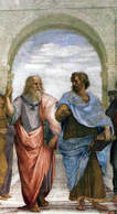
Aristotle lived in Greece more than three hundred years before the Common Era (or Before Christ). In Aristotle’s time, most people believed that many gods ruled the universe. A happy god might allow an abundant harvest while an angry god would show his fury with storms or earthquakes. Aristotle decided he could understand the world through observation and by using logic and reason. Later scientists called Aristotle the Father of Natural Science because centuries after the ancient scholar's death, his methods formed the basis of the scientific method.
Most people in Aristotle’s time believed the earth was flat, but Aristotle concluded that the earth was round. The Greek thinker realized that a lunar eclipse occurred when the earth came between the sun and the moon. He observed that the shape of the earth’s shadow was round. The shadow would have a much different shape if the earth was flat. Next, Aristotle considered the position of the North Star. The further north a person journeyed, the closer the North Star seemed to move to the middle of the sky. If a person traveled south of what we now call the equator, he or she could not see the North Star at all. Finally, Aristotle watched ships sailing into port. He noticed that at a distance, he could see the tops of the ships' sails before he saw the rest of the ship. Aristotle deduced that this was because of the curvature of the earth. We know today that Aristotle’s conclusions were correct because humans have traveled around the globe and we have seen pictures of the earth from space.
Most people in Aristotle’s time believed the earth was flat, but Aristotle concluded that the earth was round. The Greek thinker realized that a lunar eclipse occurred when the earth came between the sun and the moon. He observed that the shape of the earth’s shadow was round. The shadow would have a much different shape if the earth was flat. Next, Aristotle considered the position of the North Star. The further north a person journeyed, the closer the North Star seemed to move to the middle of the sky. If a person traveled south of what we now call the equator, he or she could not see the North Star at all. Finally, Aristotle watched ships sailing into port. He noticed that at a distance, he could see the tops of the ships' sails before he saw the rest of the ship. Aristotle deduced that this was because of the curvature of the earth. We know today that Aristotle’s conclusions were correct because humans have traveled around the globe and we have seen pictures of the earth from space.
Copernicus and the Heliocentric Universe:
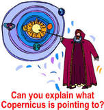
Imagine you discovered something that nobody would believe. Even worse, your discovery might get you into serious trouble. That’s what happened in 1514. Nicolaus Copernicus was a deeply religious man. He worked for the church as a physician for the poor people of Poland by day, but at night he studied the heavens. Copernicus measured the relative angles of the sun, moon, and planets and concluded that the universe is heliocentric, or that it revolves around the sun. Helios is a word used by the ancient Greeks for the sun. In Copernicus' time, almost everyone believed that the earth was the center of the universe. People believed that the sun and other heavenly bodies moved in circles around the earth.
Copernicus feared that his ideas did not agree with how some people interpreted the Bible, so he circulated his opinions anonymously. Martin Luther, a leading religious figure of the day, said of Copernicus, "Scripture tells us that Joshua commanded the sun to stand still, and not the earth.” A legend about Copernicus tells of a book he wrote about the heliocentric universe. A friend placed the book in his hands a few days after he lost consciousness from a stroke. Copernicus awoke to see that his work was published, and then died peacefully. We don’t know if that story is true, but it shows how fearful people at that time were of challenging long held beliefs, even if the beliefs are proven wrong.
Copernicus feared that his ideas did not agree with how some people interpreted the Bible, so he circulated his opinions anonymously. Martin Luther, a leading religious figure of the day, said of Copernicus, "Scripture tells us that Joshua commanded the sun to stand still, and not the earth.” A legend about Copernicus tells of a book he wrote about the heliocentric universe. A friend placed the book in his hands a few days after he lost consciousness from a stroke. Copernicus awoke to see that his work was published, and then died peacefully. We don’t know if that story is true, but it shows how fearful people at that time were of challenging long held beliefs, even if the beliefs are proven wrong.
Galileo:
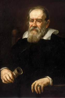
Like Aristotle and Copernicus, Galileo Galilei learned from observing and measuring what he saw. Galileo lived in Pisa, a city on the northwestern coast of the Italian peninsula. In 1583, when Galileo was nineteen-years-old, he observed a priest swinging an altar lamp. No matter how wide the swing of the lamp, it seemed the time it took to move from one end to the other was always the same. Galileo had discovered what scientists today call isochronism, and his observations led to the development of the pendulum clock.
Galileo heard stories of a tool that used curved pieces of glass to magnify distant objects. The Italian scientist was unable to purchase the instrument we now call a telescope, so he built a telescope on his own. When Galileo observed the heavens, he made several discoveries that differed with Aristotle's theory of an earth centered universe.
In Galileo's time, many people believed in a geocentric universe where all heavenly objects revolved around the earth. Galileo's discovery of moons orbiting Jupiter disproved that theory. While Galileo's discovery did not prove the earth travels around the sun, it disagreed with the way many people interpreted the Christian Bible. In 1616 Pope Paul V, the leader of Galileo's Catholic Church, commanded that the scientist never again "defend or hold" the idea of a heliocentric universe. Though he was a deeply religious man, Galileo continued to make new discoveries and continued to promote Copernicus' theory of a universe that revolved around the sun. Sixteen years later, Galileo went on trial for heresy. Heresy is an opinion or belief that disagrees with the official position of the church. The church found Galileo guilty of teaching that the sun is the motionless center of the universe and sentenced him to house arrest for the remaining nine years of his life. Galileo accepted his sentence, but he continued to write and study from his home.
Longitude and Latitude:
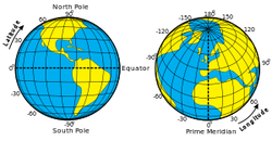
The grid of intersecting lines on a globe enables us to identify every location on Earth with a set of numbers or letters. The ancient Babylonians divided any circle or sphere into 360 degrees. The symbol for degree is °. Ptolemy was a Greek thinker who borrowed the Babylonians’ ideas as he wrote one of the first books on geography. Ptolemy wrote that the furthest point at the right or left side of a circle or a sphere is 90 degrees from the top. There are 180 degrees between any two sides of a circle or sphere. This means that the north and south poles are 180 degrees apart from one another, and both are 90 degrees from the equator. Geographers use Ptolemy’s calculations to create Lines of Latitude and Lines of Longitude.
Lines of Latitude are imaginary lines that circle the globe from east to west. Lines of Latitude are called parallels because the lines parallel, or run in the same direction as the equator. The equator is the imaginary line that is as far away from the North Pole as it is from the South Pole. Lines of Longitude intersect the equator at right angles but end at the North and the South Poles. Lines of Longitude are also called meridians. Meridian comes from a Latin word that means midday. The sun crosses each meridian in the middle point between sunrise and sunset.
In 1884, the International Meridian Conference chose to make the line at 0 ° longitude runs through the Royal Observatory in Greenwich, England, though they could have chosen any spot on earth. They called the line at 0 ° longitude the Prime Meridian. Meridians are counted east and west from the Prime Meridian. St. Louis, Missouri is 90 ° west of the Prime Meridian, so it is one-fourth of the way around the earth from the Prime Meridian. The International Date Line is 180 °--as far away as possible--from the Prime Meridian. When it is noon along the Prime Meridian, it is midnight along the International Date Line.
Geographers also divide the Earth into hemispheres. Hemi- is a prefix that means half. Everything north of the equator is in the Northern Hemisphere while everything south of the equator is in the Southern Hemisphere. The Western Hemisphere is west of the Prime Meridian and the Eastern Hemisphere is east of the Prime Meridian. The hemispheres both end at the International Date Line. The United States is in the Northern and Western Hemispheres. The White House in Washington, D.C. is 80 degrees west of the Prime Meridian and 26 degrees north of the equator, or 39 °N,77 °W.
The Fourth Dimension:

Draw a straight line on a piece of paper. The line has only one dimension. Now draw a square. The square has two dimensions. A dimension is a property of space, or an extension in a given direction. Now, if you are able, draw a cube. A cube has three dimensions.
When you watch a movie in "3-D," or three dimensions, you are probably required to wear special glasses that trick your mind into seeing depth on a flat screen
We will also work with a fourth dimension—time. The distance from the floor to the top of your head is your height. Stretching your arms out, the distance from one fingertip to the other is an example of width. Putting your hands in front of you provides you with the third dimension—depth. Think about the future. It is likely that your size and shape will change over time, so in this case, time can be considered the fourth dimension.
The sizes and shapes of nations and regions can also change over time. In 1776, the United States consisted of only thirteen states along or near the coast of the Atlantic Ocean. By 1912, 48 states stretched across the mainland of North America. The United States expanded even further west as Alaska and Hawaii joined the union in 1959. Soon we will study the lands between the Tigris and Euphrates Rivers in a land that today is part of the nation of Iraq.
Seasons:
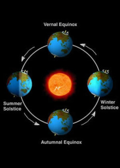
Over the course of a year, the earth experiences changes in weather, ecology and hours of daylight. These changes are called seasons. Seasons are the result of the yearly revolution of the earth around the sun and the tilt of the earth. The earth’s axis is an imaginary line that runs through the middle of the earth from the North Pole to the South Pole. The axis of the earth is tilted about 23½ degrees. The tilt of the earth remains the same as the earth follows its yearly path around the sun. This path is known as an orbit.
In June, the Northern Hemisphere tilts toward the sun, so the people in the Northern Hemisphere have longer and warmer days. The days are shorter and colder in the Southern Hemisphere in June because the earth tilts away from the sun. The days start getting shorter in the Northern Hemisphere and longer in the Southern Hemisphere after June 21. Daytime lasts exactly as long as nighttime on the first day of autumn (September 21) and the first day of spring (March 21). The first day of winter in the Northern Hemisphere, on December 21, is the shortest day of the year in the Northern Hemisphere and the longest day of the year in the Southern Hemisphere.
Seasonal changes are more pronounced as you move further away from the equator. The tropics are areas 23½ degrees north and south of the equator. The tropics receive direct rays from the sun all year long, so tropical regions have less seasonal variation than the temperate and polar regions that cover the rest of the earth. Many plants and animals in the areas beyond the tropics have adapted to the changing of the seasons. Seasonal changes cause many plants to become dormant in the winter months, and some animals follow seasonal journeys known as migrations.
The days get longer in summer and shorter in winter as you move from the equator. It’s dark on a summer night in Florida by 8:30 p.m., but in Vermont, there will still be some daylight at 10:00 p.m. The situation is reversed in the winter, where the sun will go down in Vermont by 3:45 p.m. while it remains light in Florida until 5:15 p.m. Northern Alaska is called the “Land of the Midnight Sun” because it never gets dark during the summer months. That part of the earth is facing the sun all day and all night. Antarctica never sees daylight during those months. Six months later in December and January, northern Alaska never sees the sun while people visiting Antarctica can see the sun at midnight.
Time and Time Zones:
Days and nights occur because the earth spins on an axis. The sun illuminates approximately half of the earth’s surface, but since the earth is constantly turning, we divide the earth into twenty-four time zones; one for each hour of the day. Some time zone boundaries zigzag so that people living in one region or country can have the same time.
Until the nineteenth century, each city kept local time. Clocks were not often very accurate, but they could be synchronized, or matched, with a sundial. Railroad engineers created the first time zones in Great Britain. Railroad would use the same tracks to send trains in different directions so an inaccurate clock could cause a disaster. A Canadian named Sanford Fleming first proposed the idea of universal time zones; by 1900, most nations began to use what became known as “standard time.”
The time along the prime meridian in Greenwich, England, is known as Greenwich Mean Time, or GMT. People communicating across two different parts of the globe often use Greenwich Mean Time. The east coast of the United States is five time zones behind GMT, so if it is midnight in Greenwich it is 7:00 p.m. in Florida. Most of the United States sets their clocks ahead one hour in the summer, so during Daylight Saving Time the east coast of the United States is four hours behind Greenwich Mean Time.
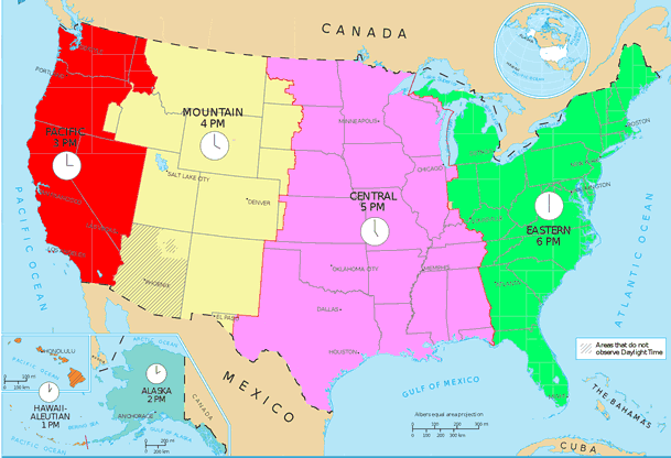
There are four time zones in the continental United States. The continental United States refers to the forty-eight contiguous states and does not include Alaska or Hawaii. The time zones are Eastern, Central, Mountain, and Pacific. You might notice that live television programs often begin at 8:00 Eastern, 7:00 Central, 6:00 Mountain and 5:00 Pacific. Alaska is an hour behind Pacific Time and Hawaii is two hours behind Pacific Time.
For convenience, almost all of Alaska uses a single time zone. During the period when Daylight Saving Time is not in use, the sun is overhead at about noon in Alaska’s capital, Juneau. Juneau is in the eastern portion of Alaska. Nome is in western Alaska, and while Nome has the same time zone as Juneau, the sun is directly overhead as late as 3:08 p.m.
Until the nineteenth century, each city kept local time. Clocks were not often very accurate, but they could be synchronized, or matched, with a sundial. Railroad engineers created the first time zones in Great Britain. Railroad would use the same tracks to send trains in different directions so an inaccurate clock could cause a disaster. A Canadian named Sanford Fleming first proposed the idea of universal time zones; by 1900, most nations began to use what became known as “standard time.”
The time along the prime meridian in Greenwich, England, is known as Greenwich Mean Time, or GMT. People communicating across two different parts of the globe often use Greenwich Mean Time. The east coast of the United States is five time zones behind GMT, so if it is midnight in Greenwich it is 7:00 p.m. in Florida. Most of the United States sets their clocks ahead one hour in the summer, so during Daylight Saving Time the east coast of the United States is four hours behind Greenwich Mean Time.
There are four time zones in the continental United States. The continental United States refers to the forty-eight contiguous states and does not include Alaska or Hawaii. The time zones are Eastern, Central, Mountain, and Pacific. You might notice that live television programs often begin at 8:00 Eastern, 7:00 Central, 6:00 Mountain and 5:00 Pacific. Alaska is an hour behind Pacific Time and Hawaii is two hours behind Pacific Time.
For convenience, almost all of Alaska uses a single time zone. During the period when Daylight Saving Time is not in use, the sun is overhead at about noon in Alaska’s capital, Juneau. Juneau is in the eastern portion of Alaska. Nome is in western Alaska, and while Nome has the same time zone as Juneau, the sun is directly overhead as late as 3:08 p.m.
Daylight Saving Time:

Most western nations advance the clock ahead one hour during the summer months. We call this period Daylight Saving Time. Benjamin Franklin originally suggested the idea. He wanted to take advantage of the additional daylight time in the summer when many people were sleeping. Daylight Saving Time was first adopted to replace artificial lighting so they could save fuel for the war effort in Germany during World War I. This poster reminds farmers that the extra hour of daylight will provide more time for farming.
The United States temporarily adopted Daylight Saving Time in 1918. America was fighting World War I, and American leaders concluded that the additional hour of daylight would save fuel needed for the war effort. The war ended, so the national experiment lasted only one year, but many states continued to observe Daylight Saving Time on their own. Congress set the clocks ahead again in 1942 during the Second World War and again during an energy shortage in 1973.
In addition to energy savings, many retail business owners favor Daylight Saving Time because it allows more daylight hours for shopping. There is also some evidence that suggests that additional daylight contributes to fewer automobile accidents and a decrease in violent crime.
In the United States, every state but Hawaii and Arizona observes Daylight Saving Time from the second Sunday in March to the first Sunday in November. Hawaii is closer to the equator than the other states, and since the amount of daylight does not vary much, the Hawaiians feel Daylight Saving Time is unnecessary. Summer temperatures in Arizona often reach 100, so lawmakers in the Grand Canyon State decided it would be better to end the day early so Arizonans could enjoy an extra hour of cooler evening weather in the summer.
When will Daylight Saving Time Begin and End in the United States?
2013: March 10 to November 3
2014: March 9 to November 2
2015: March 8 to November 1
2016: March 13 to November 6
2017: March 12 to November 5
2018: March 11 to November 4
Measuring Time:
The United States Naval Observatory in Washington, D.C. is home to the "Master Clock," an atomic timepiece that sets the official time in the United States.
It is now possible to buy a watch or clock that synchronizes itself with the United States Naval Observatory. More than fifty clocks at the Naval Observatory measure the frequency emitted by atoms of the metallic element cesium. These atomic clocks are accurate to within one second every 1,400,000 years. In fact, our ability to measure time is more accurate than the stability of the earth. Scientists from the International Earth Rotation and Reference Systems Service add a “leap second” to the clock in many years because ocean tides are causing the earth to turn slightly slower.
Humankind first measured the time of the day with sundials, but sundials were usable only on sunny days. In ancient Rome, lawyers would be scheduled to speak in the Forum ante medium-before the sun reaches its highest point, or post medium-after the sun reaches its highest point. Today the abbreviations a.m. and p.m. reflect this practice.
The first mechanical clocks in Europe had no numbers. Most people could not read, and technology to create a clock face was not initially in place. Clocks would count out the hour by ringing a large bell high in a tower. The term o’clock is a contraction for “of the clock.”
The Romans borrowed the seven-day week from the Hebrews. The week is associated with the Old Testament, where God created the world in six days and rested on the seventh. The Romans once had an eight-day week, but shortened their week when they adopted Christianity.
Our months correspond with the phases of the moon. A full moon occurs every 27 days, but in time we have adjusted the calendar in order make twelve months equal to the solar year.
Calendars and Years:

The earth travels around the sun every 365.242199 days, or what we call a “solar year.” The ancient Romans devised the Julian calendar that lasted 365.25, but the solar year is eleven minutes and fourteen seconds shorter. This slight difference added up over time.
By 1582, the Julian calendar was ten days behind the solar calendar. Most western nations began using the Gregorian calendar, named for Pope Gregory XIII. The Gregorian Calendar synchronized the calendar year with the solar year by skipping the next ten days. The day after October 4, 1582 was October 15, 1582. The governments of England and its American colonies did not follow the teachings of the pope, so they did not adjust to the Gregorian calendar until 1752. By this time, the Gregorian calendar was twelve days ahead of the Julian calendar.
Most of our calendar years last 365 days, but every four or eight years we add one day to February. February usually has only 28 days, but the month lasts a day longer in what we call “leap years.” Years divisible by four are usually leap years. The last four leap years were 2008, 2004, 2000, and 1996. Our next leap year will be 2016.
Adding a leap year every four years would make the calendar year last 365.25 days. The time it takes for the earth to orbit the sun is 365.242581 days, which is .007419 of a day shorter, so the Gregorian Calendar makes other adjustments. Centennial years are years that end in 00. Centennial years are not leap years unless they are divisible by 400. This means that 1700, 1800, and 1900 were not leap years, but 2000 was. The next time someone says that there are 365 days in a year; you’ll have a lot of corrections to offer!
Map Projections:
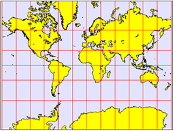
If you tried to flatten a tennis ball, the sides would split and the shape would change. The same thing would happen if you tried to flatten a world map onto a piece of paper. It is impossible to create a two-dimensional map of the three-dimensional earth without stretching some places. Mapmakers call this stretching distortion. A globe can show size, shape, distance, and direction accurately, but since a flat map cannot be three-dimensional, we have to use map projections. A map projection is a way to show a drawing of the earth on a flat surface. All flat maps have distortion, so we use different map projections to meet different needs.
In 1569, Gerardus Mercator created a map where parallels and meridians cross at right angles. The Mercator Projection is excellent for navigation because it shows direction clearly. The Mercator Projection, however, has a great deal of distortion. In order to get the parallels and meridians to cross at right angles, Mercator stretched the areas further away from the poles and squeezed the areas closer to the equator.
An equal area map displays the shapes and sizes of things more accurately than a Mercator Projection. The Mollweide Projection is one of several equal area maps. The Mollweide Projection sacrifices accuracy of angle and shape in favor of accurate proportions in area. Compare Greenland and Africa on the two projections: Africa is actually fourteen times larger than Greenland, but on a Mercator Projection, the two regions are about the same size.
Many modern mapmakers use complicated mathematical formulas that combine the advantages of the Mercator Projection and equal area maps. The border of the western United States and Canada is the longest straight border in the world. Some map projections depict the border as a straight line; on other map projections you will notice a slight bend due to the curvature of the earth.
The Six Essential Elements of Geography:
The Merriam-Webster dictionary describes geography as “a science that deals with the description, distribution, and interaction of the diverse physical, biological, and cultural features of the earth's surface. Simply put, we will learn about the features of the earth and how living things interact and change the earth. Scholars have divided the study of geography into six parts called “The Six Essential Elements of Geography.” A geographically informed person knows:
1. The World in Spatial Terms
a. How to use maps and other geographic representations, tools, and technologies to acquire, process, and report information from a spatial perspective
b. How to use mental maps to organize information about people, places, and environments in a spatial context
c. How to analyze the spatial organization of people, places, and environments on earth's surface
2. Places and Regions
a. The physical and human characteristics of places
b. That people create regions to interpret earth's complexity
c. How culture and experience influence people's perceptions of places and regions
3. Physical Systems
a. The physical processes that shape the patterns of earth's surface
b. The characteristics and spatial distribution of ecosystems on earth's surface
4. Human Systems
a. The characteristics, distribution, and migration of human populations on earth's surface
b. The characteristics, distribution, and complexity of earth's cultural mosaics
c. The patterns and networks of economic interdependence on earth's surface
d. The processes, patterns, and functions of human settlement
e. How the forces of cooperation and conflict among people influence the division and control of earth's surface
5. Environment and Society
a. How human actions modify the physical environment
b. How physical systems affect human systems
c. The changes that occur in the meaning, use, distribution, and importance of resources
6. The Uses of Geography
a. How to apply geography to interpret the past
b. How to apply geography to interpret the present and plan for the future
References:
Dowling, Mike. "Time and Space." www.mrdowling.com. Updated January 13, 2014 . Web. Date of Access. <http://www.mrdowling.com/601-essential.html>
www.history.com (The History Channel)
McGraw-Hill Networks Company, Inc.
Dowling, Mike. "Time and Space." www.mrdowling.com. Updated January 13, 2014 . Web. Date of Access. <http://www.mrdowling.com/601-essential.html>
www.history.com (The History Channel)
McGraw-Hill Networks Company, Inc.
